
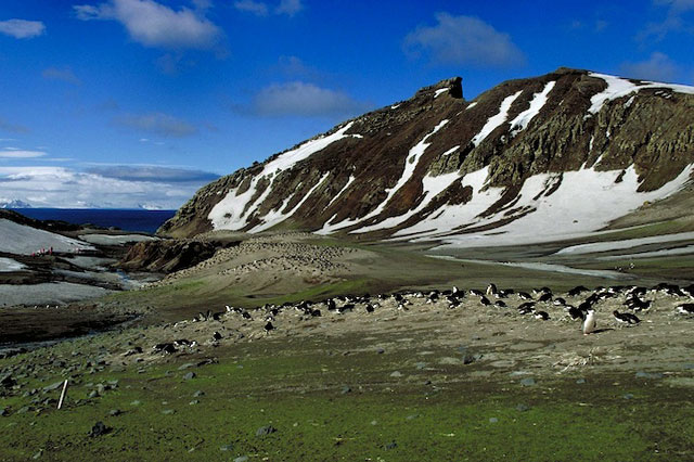
 Photo Credit: ©Ron Naveen/Oceanites Inc. |
Chinstrap penguins at Baily Head, Deception Island, off the Antarctic Peninsula. Researchers have documented at least a 50 percent decline in the population over the last 20 years. Various factors may be involved, but scientists don't believe tourism is a contributing factor. |
Posted September 7, 2012
That’s the conclusion published last month in the journal Polar Biology by a team of researchers that spent 12 days in December 2011 counting individual penguin nests on the remote Antarctic island. The census found nearly 80,000 breeding pairs, with about 50,000 at a location called Baily Head.
The results were compared against a 1986-87 survey, refined with a simulation designed to capture uncertainty in the earlier population estimate by British Antarctic Survey (BAS)
It had already been known that the colony was in steady decline but no one had been able to quantify the plummet in population until now.
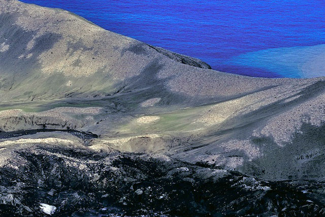
Photo Credit: ©Ron Naveen/Oceanites Inc.
An aerial view of chinstrap penguin colony at Baily Head, Deception Island.
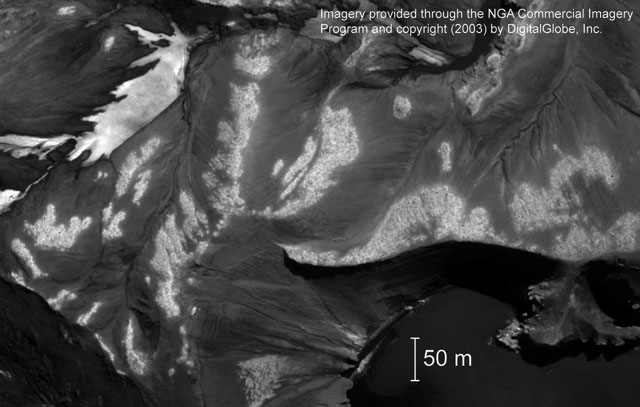
Photo Credit: ©DigitalGlobe Inc.; Image provided by National Geospatial-Intelligence Agency Commercial Imagery Program
A satellite image shows chinstrap penguin colonies at Baily Head, Deception Island, in 2003.
There has been concern by nations party to the Antarctic Treaty System
However, the drop in the chinstrap population at Baily Head is consistent with population declines of the species at other locations, including sites that receive little or no tourism, according to Ron Naveen, founder of Oceanites Inc.
Previously, the researchers had published results from surveys of 29 chinstrap colonies that found significant declines at 16 sites and increases at only seven. Another one of the so-called brushtailed penguins, Adélie numbers are also crashing along the northwestern Antarctic Peninsula. The third brushtailed species, gentoos, appears to be increasing in numbers. [See previous story — The big picture: Broad-scale study suggests sea ice not driving changes in penguin populations.]
Pressures from climate change are believed to be hurting the Adélie and chinstrap colonies off the Antarctic Peninsula, where temperatures have increased by about 3 degrees Celsius in the summer and almost double that in the winter. In particular, the Adélies rely on sea ice as a key habitat. And while subantarctic chinstraps aren’t as reliant on the seasonal pack ice, which is also shrinking in duration and extent, food sources such as krill graze on the algae that grow under the ice. Other factors may also be in play.
The team backed up its census data with a comparison of satellite imagery between the 2002-2003 and 2009-2010 summer seasons. During that seven-year period, the chinstrap population dropped by an estimated 39 percent, though there was a larger degree of uncertainty because of the difficulty involved in estimating nest density from the satellite imagery.
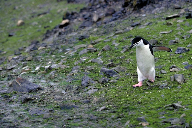
Photo Credit: ©Ron Naveen/Oceanites Inc.
A chinstrap penguin at Baily Head, Deception Island.
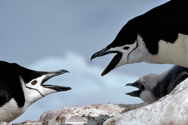
Photo Credit: ©Ron Naveen/Oceanites Inc.
Chinstrap penguin breeding pair with chick at Baily Head, Deception Island.
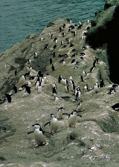
Photo Credit: ©Ron Naveen/Oceanites Inc.
Chinstrap penguins return to their nests from the small cove on the southwestern side of Baily Head, Deception Island.
Despite the uncertainty, there was a remarkable correspondence between the field census and the satellite image counts, according to Lynch.
“The two census estimates were completed entirely independently using separate ‘pools’ of information,” she explained. “We were completely shocked at how close the two census estimates were to one another. I think this is a really incredible validation that the high-resolution satellite imagery can produce census data of the same quality as can be obtained in the field and, potentially, over a much larger scale.”
Lynch is a proponent of remote-sensing conservation, a growing field that uses satellite imagery to monitor wildlife populations. The technique has been used in the Antarctic to assess seal populations as well as penguin colonies. [See previous story — Eyes in the sky: Scientists use satellites to track health of seal, penguin populations in Antarctica.] She is also an advisory member of the Polar Geospatial Center (PGC)
Fortunately, for seasoned and enthusiastic field hands like Naveen, there’s still a need to visit and census the animals on the ground.
“The reason that we were able to use the satellite imagery so successfully is because we have a lot of ground truthing data — density estimates, photo-documentation, personal experience — and as we start expanding this approach, our investment in regional-scale census work is going to pay major dividends,” Lynch said.
Of course, the fieldwork isn’t as romantic as it sounds. The 12-day stint on Deception Island was as much a function of nasty weather — persistent clouds, precipitation and at times gale-force winds — as the desire to fill in a key gap in the Oceanites dataset, according to Naveen.
“Deception [has] never been fully censused in one season, let alone 12 days. Unfortunately, the weather was such that we never left Deception,” he said. “I wanted to make sure we had those data in hand and this coming season we’ll be doing more ‘gap’-filling work.”
In 18 years, Oceanites teams have conducted more than 1,200 census visits at 169 locations over an area covering more than 100,000 square kilometers. Naveen said he is eager to continue the census work, especially with the more sophisticated analytical tools employed by Lynch and her lab.
“Assessing and analyzing the changes now occurring in the peninsula is an engrossing and thoroughly complex undertaking,” he said. “The statistics and photo-analytical resources we have available, and the new ones that we’re developing, particularly in regard to using satellite photo-documentation … will give all of us a better understanding of what’s driving change in the vastly warming peninsula ecosystem.”
source


No comments:
Post a Comment